The objective of this blog is to show the ways drone-based topographic mapping can be utilized in construction projects to aid more efficient plan, safer execution, and more precise decision-making. We hope to assist contractors, architects, and developers in comprehending how aerial mapping can be integrated into construction workflows and how it can add tangible value from the beginning of construction to the project’s completion.
This guide is focused on real-world usage cases, construction-ready information, and tested methods utilized by the modern-day site teams that require reliable terrain information without affecting the work on the ground.
What if you could understand every slope, dip, and elevation change on a construction site before heavy equipment ever rolls in?
That single question explains why site data matters more today than ever before. Construction teams no longer have the margin for guesswork, delayed surveys, or outdated maps. When budgets are tight and timelines are strict, clarity on the ground is not optional; it is essential.
Did you know that grading and earthwork errors are among the top reasons construction projects exceed their budgets? Industry research shows that inaccurate elevation data often leads to rework, drainage issues, and scheduling delays that ripple through an entire project lifecycle.
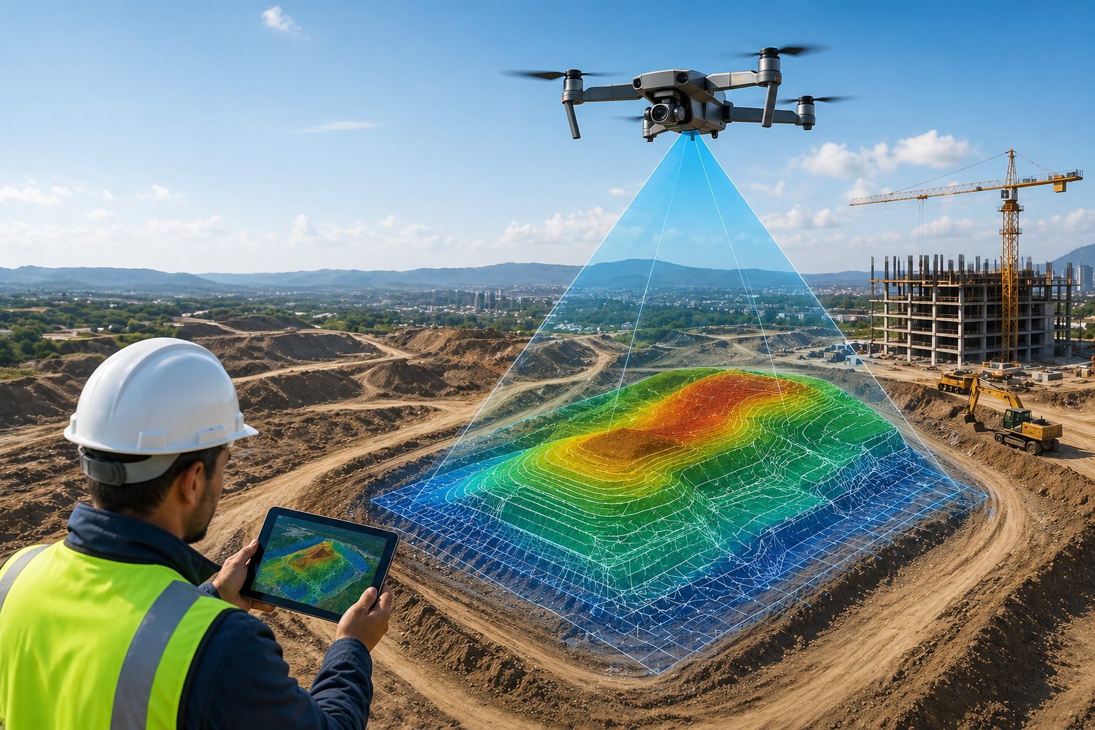
This is where drones for topographic mapping are now playing a practical, reliable role in modern construction. These tools help teams see site conditions clearly, plan smarter, and reduce risk right from the start.
Construction has always relied on ground truth. But here’s the thing: traditional survey methods were built for a slower pace. Today’s projects move fast, span large areas, and change frequently. Site conditions can look very different in a few weeks, especially during early earthwork phases.
Topographic mapping is the process of measuring land shape, elevation, and surface features. For construction, this data aids in decisions regarding drainage foundations, road layout, and volume estimations. If teams are relying on inaccurate or insufficient information, even small mistakes turn into expensive issues.
This shift has pushed many construction professionals toward aerial data collection. Drone‑based surveys offer a practical way to capture detailed terrain data without slowing work. And when done correctly, these surveys support smarter, safer construction planning from day one.
Construction mapping used to refer to feet on the ground with manual measurement and lengthy turnaround times. This method still works in certain instances, but it’s no longer appropriate for the scale or speed of the modern-day projects.
Construction teams today are expecting faster insight and more accurate terrain data.
Photogrammetry mapping drones capture overlapped aerial images, which the software converts into accurate surface models. These models depict elevation changes, features of the site, and contours over vast areas in a relatively quick time.
When compared to surveys that are manually conducted This method:
One civil engineer we talked to told us that early drone surveys allowed their team to identify a grading issue prior to excavation beginning. The fix was on paper for several hours. Repairing it later would take several weeks.
Construction planning now depends on visual clarity. Teams want to see slopes, water flow paths, and cut‑and‑fill areas early. Digital site data allows planners to evaluate options before making expensive commitments.
This approach improves communication between engineers, contractors, and owners. Everyone works from the same view of the site.
Here’s the simple truth: construction mistakes often begin long before materials arrive on site. Most problems start with incomplete site understanding.
A digital elevation model shows the height of the ground surface across a site. DEMs support:
When elevations are off, water flows where it shouldn’t. Foundations shift. Crews spend time correcting avoidable issues.
3D terrain models provide clear and precise information about how the land changes across the project area. Instead of interpreting contour lines by themselves, the teams can see the slopes and transitions.
This assists planners in explaining the conditions of the site to people who might not have technical knowledge. Clear and concise images often avoid miscommunications in the early stages.
Modern construction workflows are built around speed, accuracy, and flexibility. Aerial mapping aligns well with these goals.
In the process of pre-construction, teams on site typically have deadlines that are tight to verify the feasibility. When construction is in progress, they require updated information without interfering with work.
This is where drones for topographic mapping prove especially useful.
In land development, early terrain data influences everything that comes next. Drainage paths, road access, and buildable areas all depend on elevation.
A developer planning a multi‑lot residential project shared that early aerial mapping helped them avoid unexpected regrading costs later. The data showed subtle elevation changes that were easy to miss from ground views alone.
Active sites change quickly. Stockpiles grow and shrink. Cuts deepen. Slopes adjust.
Construction site surveying with drones allows teams to:
This approach limits interruptions while still keeping planners informed.
Drone‑based mapping is now used across many construction segments, from infrastructure to commercial development.
Earthwork success depends on knowing how much material to move and where. Topographic mapping using UAV systems allows:
Accurate data on terrain can help teams avoid the need to haul in excess soil or order the wrong fill.
Linear infrastructure pipelines, projects, roads and pipelines, roads, and utilities typically extend over long distances and are often surrounded by unsteady terrain.
Drone surveys for construction sites let teams collect data on elevations that are consistent across entire corridors, including places that are difficult to access on foot.
Construction leaders often ask whether aerial mapping can truly match traditional surveys. The answer depends on execution, tools, and quality control.
When flown properly, photogrammetry mapping drones produce dense surface data suitable for many planning tasks. Accuracy improves further when combined with established ground control methods.
This level of precision supports:
The reduction of foot traffic on shaky slopes or around heavy equipment can reduce the risk. Surveyors using aerial data collection remain free of dangers while giving useful data.
This safety feature is often ignored, but it makes an impact on busy job websites.
Contemporary drone surveying depends on an amalgamation of both software and hardware, which work in conjunction.
These tools allow for accurate data capture as well as high-quality outputs.
Aspect | Traditional Surveying | Drone‑Based Mapping |
Time on Site | Longer | Shorter |
Safety Risk | Higher | Lower |
Area Coverage | Limited | Wide |
Update Frequency | Infrequent | Flexible |
While drones are powerful tools, results depend on experience, planning, and proper data handling.
Professional drone topographic survey services ensure that data meets construction needs and integrates smoothly with engineering workflows.
Construction teams often look for:
Working with experienced providers helps avoid data gaps and costly rework. DroneLiDARMapping focuses on providing construction‑ready datasets that support real‑world decision‑making without slowing projects.
Later in the project lifecycle, drone topographic survey services remain useful for validating progress and confirming as‑built conditions.
Land mapping services from drones are most beneficial when they align with the construction objectives. This is a way of knowing how the terrain data can be incorporated into grading plans, drainage plans, and schedules.
Construction leaders often say that clear elevation data early on saves far more time later.
DroneLiDAR Mapping has worked with contractors, developers, and engineers who need dependable site insight, not experimental data. That focus on practical results sets experienced providers apart.
Construction teams are successful by relying on solid data. Planning and controlling costs are made easier through accurate terrain data.
Construction sites can be mapped more efficiently with aerial drones without slowing construction or creating hazards. Construction workflows can benefit from Aerial Mapping when coupled with skilled guidance and ready-to-build outputs.
If your project is infrastructure development, land development, or commercial development, a precise understanding of the site can make everything.
When planned and executed correctly, drone surveys produce terrain data accurate enough for grading analysis, volume calculations, and early design decisions.
In many construction phases, drones support and enhance traditional surveys. Licensed ground surveys remain important for legal boundaries and final certifications.
The frequency depends on the activity of the project. Sites that have heavy earthwork could get regular updates, whereas slower phases need fewer flights.
Yes. The size of aerial surveys makes them ideal for large-scale development and infrastructure projects with mixed terrain.
Drone Lidar Mapping company provides nationwide drone lidar mapping. Topographic Surveys, boundry ALTA Land Surveys, drone land surveys and construction aerial mapping & monitoring-delivering high precision aerial data to help you plan, build, and succeed.