Land Mapping and LiDAR Services: Costs, Benefits & Key Applications

Objective

This article explains what land mapping and LiDAR services are, how much they cost, and where they are being used across construction, real estate, forestry, mining, agriculture, and infrastructure projects. It also explores the key benefits of LiDAR technology, including improved accuracy, faster data collection, reduced surveying time, and better project planning. Readers will gain a clear understanding of how modern land mapping solutions help businesses, developers, engineers, and property owners make informed decisions while improving efficiency and reducing operational risks.

Key Takeaways
  • Land mapping and LiDAR services deliver centimeter-level accuracy in far less time than traditional surveys.
  • LiDAR drone survey costs depend on site size, terrain, and deliverable type — but are usually more affordable than ground surveys.
  • Drones for surveying and mapping can cover hundreds of acres in a single day.
  • ALTA survey requirements still need a licensed PLS — LiDAR speeds up the data collection phase.
  • Top applications include construction, flood modeling, forestry, utility corridors, and solar projects.

Introduction

The way land is surveyed and mapped has changed a lot over the past few years. What used to take weeks of fieldwork can now be done in a day or two using drone-mounted LiDAR sensors. For construction companies, developers, and engineers, that’s a big deal — not just for speed, but for the quality and reliability of the data they get back.

At Drone Lidar Mapping, we work with clients nationwide on projects from small construction lots to large infrastructure corridors. The question we hear most before anything else is: what does this cost, and is it actually worth it? That’s exactly what this guide answers.

Table of Contents

  1. Introduction to Land Mapping and LiDAR Services
  2. What Are Land Mapping and LiDAR Services?
  3. How LiDAR Technology Works in Modern Surveying
  4. Key Benefits of Land Mapping and LiDAR Services
  5. LiDAR vs Traditional Land Surveying Methods
  6. Common Applications Across Different Industries
  7. Understanding the Cost of LiDAR Mapping Services
  8. Factors That Affect Land Mapping Project Pricing
  9. Why Businesses Are Choosing Drone LiDAR Mapping
  10. Choosing the Right Land Mapping Service Provider
  11. Future Trends in LiDAR and Aerial Mapping
  12. Final Thoughts
  13. Frequently Asked Questions (FAQs)

What Are Land Mapping and LiDAR Services?

LiDAR Drone Survey

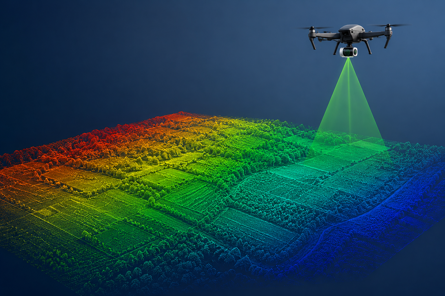
Land mapping and LiDAR services involve capturing accurate, three-dimensional spatial data about a piece of ground using laser-based technology. LiDAR stands for Light Detection and Ranging. It fires rapid laser pulses from a drone-mounted sensor and measures how long each one takes to bounce back, producing a detailed 3D point cloud of the terrain.

What makes LiDAR especially useful is that it can penetrate tree canopy. The laser pulses pass through gaps in leaves and branches to reach the actual ground below — something standard aerial photography can’t do. For forested areas, wetlands, or any site with dense vegetation, this makes a real difference.

Typical deliverables include digital elevation models (DEMs), contour maps, bare-earth terrain models, and georeferenced orthomosaic maps — all of which work directly with CAD, BIM, and GIS platforms.

LiDAR Drone Survey Cost: What to Expect

The biggest misconception about lidar drone survey cost is that it must be expensive. In reality, drone-based LiDAR often costs less than traditional ground surveys — especially for sites over 10 acres. Here are typical ranges:

Project Type

Area

Estimated Cost

Small site / construction lot

1–50 acres

$1,500 – $5,000

Mid-size development

50–500 acres

$4,000 – $15,000

Large area mapping

500–5,000 acres

$12,000 – $60,000

ALTA survey (LiDAR-assisted)

Varies

$3,000 – $20,000+

Accurate data up front also prevents expensive redesigns and contractor disputes later on. A LiDAR survey costing a few thousand dollars can easily save tens of thousands downstream.

Why Use Drones for Surveying and Mapping?

Using drones for surveying and mapping has become the standard across construction, real estate, and infrastructure. Here’s why:

Speed

A 500-acre ground survey can take 2–4 weeks. A drone LiDAR flight covers the same area in one or two days — meaning faster permits, earlier starts, and lower carrying costs.

Accuracy

Modern drone LiDAR achieves vertical accuracy of ±2–5 cm with proper ground control. That’s more than enough for civil engineering, grading, and BIM integration.

Safety

Drones can survey steep slopes, active quarries, flooded sites, and contaminated land without putting any crew at risk. For companies with strong safety commitments, this matters as much as the cost savings.

Repeat Coverage

Monthly drone flights give project managers ongoing volumetric data — cut/fill calculations, stockpile volumes, earthwork progress — from a consistent dataset. Traditional ground teams simply can’t match that at scale.

Understanding ALTA Survey Requirements

Most commercial real estate transactions require an ALTA/NSPS Land Title Survey. These surveys must meet strict ALTA survey requirements set by the American Land Title Association, covering property boundaries, easements, utilities, encroachments, and improvements.

LiDAR speeds up the data collection phase considerably — especially on large or complex parcels. That said, a licensed Professional Land Surveyor (PLS) must still certify and stamp all final deliverables. Always confirm a PLS is involved before hiring any drone survey firm for ALTA work.

Key Applications

Construction and Site Grading

LiDAR gives engineers an accurate baseline before ground is broken. Pre-construction, mid-project, and as-built surveys all work from the same dataset — and cut/fill calculations that used to take days now take hours.

Flood and Hydrology

Bare-earth DEMs from LiDAR feed directly into drainage design, floodplain modeling, and FEMA map updates. If outdated flood maps are affecting a property’s value, a LiDAR survey is often the first step toward correcting them.

Forestry and Natural Resources

LiDAR’s canopy penetration makes it the go-to tool for forestry — canopy height models, biomass estimates, and bare-earth mapping beneath dense tree cover are all achievable in a single flight.

Utilities and Infrastructure Corridors

Pipeline surveys, power line inspections, and road corridor mapping are all efficient with drone LiDAR. Obstacle clearance, vegetation encroachment, and structural data are captured in one pass over miles of corridor.

Solar Development

Utility-scale solar projects need precise slope analysis, drainage planning, and earthwork estimates before construction. A LiDAR survey early in the process helps optimize layout, cut grading costs, and speed up permitting.

How to Choose the Right Provider

  • FAA Part 107 certification — required for all commercial drone work in the US.
  • Licensed PLS on the team — needed for any survey deliverable that requires a legal stamp.
  • In-house data processing — better QC, faster turnaround, clearer accountability.
  • Sample data and accuracy reports — any solid firm should share these upfront.
  • Written deliverable specs — file formats, coordinate system, accuracy, and timeline before you sign.

At Drone Lidar Mapping, we combine geomatics expertise with hands-on construction project experience. Our Skyelink technology ensures your data reaches you quickly and securely, no matter the size or location of your project.

Final Thoughts

Land mapping and LiDAR services have become the practical standard for any project where accuracy, speed, and safety matter. Whether you need a construction site baseline, an ALTA-compliant deliverable, or large-scale corridor mapping, drone LiDAR gives you better data faster — and at a price that competes directly with traditional methods.

Ready to discuss your project?

Get in touch with Drone Lidar Mapping today for a tailored quote.

Frequently Asked Questions

What are land mapping and LiDAR services?

They involve collecting accurate 3D spatial data using laser sensors mounted on drones to create terrain models, elevation maps, and point clouds for construction, engineering, and land management.

Costs range from around $1,500 for small sites to $60,000+ for large area mapping projects, depending on site size, required accuracy, and deliverable type.

Yes. Drone LiDAR achieves ±2–5 cm vertical accuracy with proper ground control — meeting the requirements for civil engineering, construction, and most professional survey applications.

Yes. A licensed Professional Land Surveyor must certify and stamp ALTA survey deliverables regardless of the data collection method used.