In commercial real estate transactions, accuracy, compliance, and risk mitigation are very important issues that one has to deal with. Therefore, ALTA/NSPS Land Title Surveys are considered by many as the best in surveys for real estate. Being aware of the points of interest for the professional surveyors in connection with the ALTA project requirements, owners, initiators, moneylenders and title insurance companies can all benefit from better decision-making and avoid getting into very expensive litigation.
Drone LiDAR Mapping offers its customers the planned use of traditional know-how together with advanced drones for survey and mapping purposes. In this way, partnering with Skyelink allows the firm to provide its clients with highly accurate, regulation-compliant, and inexpensive ALTA surveys.

ALTA Survey Requirements Explained
ALTA surveys conform to the standards that were established together by the American Land Title Association (ALTA) and the National Society of Professional Surveyors (NSPS). The purpose of these standards is to ensure that all surveys are consistent, clear from a legal standpoint, and that the results are trustworthy.
The above-mentioned ALTA survey requirements are the ones that the surveyors have to follow rigorously, as the end product is frequently used for:
- Title insurance underwriting
- Commercial property transactions
- Land development planning
- Legal dispute resolution
Not complying with these requirements can lead to delays in closing or put stakeholders in risk of legal suits.
Boundary Lines and Property Corners
Surveyors always give priority to the exact detection of property boundaries. The process includes the following:
- Setting boundary lines as per deeds and lands officially recorded
- Finding and confirming property corners and monuments
- Recognizing inconsistencies between records and actual markers
With LiDAR flying surveys, surveyors can spot quickly the large or complicated parcels with very high accuracy, especially in places where vegetation is thick or the ground is uneven.
Easements and Rights-of-Way
Easements that accompany the ALTA surveys are very important. Surveyors must point out the following:
- Utility easements
- Access easements
- Shared driveways or ingress/egress paths
- Public and private rights-of-way
These are treated against the title commitments and thus their consistency is ensured. Advanced Land Mapping and LiDAR Services assist the surveyors in superimposing the already recorded easements over the terrain and surface data of high resolution, thus diminishing the risk of supervision.
Improvements and Structures
ALTA surveys do not only require the interior survey of all visible improvements but also need:
- Buildings and structures
- Parking lots and pavements
- Fences, walls, and retaining structures
- Signage and utility features
Surveyors check if the improvements are inside or outside property lines or easements. Drones used for surveying and mapping speed up the process and make it safer, especially for large commercial or industrial sites.
Access Points and Adjoining Properties
Surveyors also evaluate the relationships of a property to neighboring land. Also, they consider:
- Main road access
- Access by private ways
- Limits of adjoining lands
- Visible chances of usage by the other properties nearby
Such info is a must for lenders and buyers who are assessing the property’s usability and legal access. Surveys based on drones contribute to the visibility and documentation, particularly for the properties with limited access from the ground.
Table A Optional Items
Slightly overwhelming but quite detailed is the aspect of listing down the optional items that the client has requested among the requirements for an ALTA survey in Table A. The list may contain:
- Classification of flood zones
- Information about the zoning
- Height of the building and setbacks
- Location of utilities
Surveyors have to make it very clear which items from Table A they are including. Using LiDAR data from a drone survey helps in the accurate measuring of elevation, slope, and building size particularly for floodplain and zoning analysis.
Topography and Elevation Data
It is not necessary for all ALTA surveys, but usually topographic data is required. Surveyors search for:
- Changes in elevation
- Move patterns of water
- See and hear the lines and shapes of land
Modern land mapping and LiDAR services produce high-density elevation models that give support in planning the site better, designing the drainage system, and assessing the risk—especially in the case of large-scale developments where the risk would be much of a problem.
Accuracy Standards and Quality Control
ALTA surveys are subjected to very high accuracy criteria. Surveyors are mainly concerned with:
- Precision of measurement
- Validation of data
- Minimization of errors
- Adherence to NSPS standards
The surveyors, by the use of drone technology, are able to gather data that is consistent, and repeatable and at the same time human error is minimized. This method is time-efficient without the loss of accuracy.
Cost Considerations: What Influences the Pricing of ALTA Surveys?
The pricing of different types of surveys, namely ALTA NSPS survey and LiDAR drone survey, is a common question posed by clients. To determine the price of the project, the surveyors take into account various aspects:
- Size of the property and its location
- Degree of difficulty of the terrain
- Quantity of Table A items
- Amount of detail required
- Accessibility of the site
Although conventional surveys could consume a lot of time, the workflow empowered by drones usually cuts down the time and the cost of the field workers. Consequently, the use of drones can make the alta nsps survey cost more predictable and less expensive even in terms of maintaining compliance.
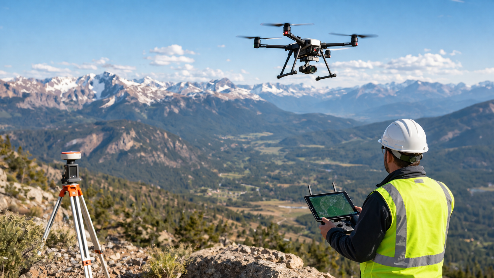
The Impact of Drone Technology on ALTA Surveys
The adoption of drones in surveying and mapping has redefined the surveyors’ approach to the ALTA requirements. The major advantages of this transformation include:
- Faster data collection
- Greater safety
- Higher accuracy
- More efficient communication with stakeholders through better visuals
We at Drone LiDAR Mapping have a dedicated team of licensed surveyors who, through our advanced drone and LiDAR systems, are provided with reliable geospatial data. This significantly helps them meet all the ALTA requirements in an efficient manner.
Final Thoughts
Grasping what surveyors expect in adhering to ALTA survey specifications brings attention to the necessity of accuracy, adherence to rules, and use of sophisticated tools. All the details count, from establishing property lines to locating easements and confirming heights.
With the merger of skilled land surveying and Land Mapping along with LiDAR Services, Drone LiDAR Mapping produces top-grade ALTA survey backing via Skyelink, which assists the clients in risk reduction, cost control, and being able to progress with assurance.