Land surveying has been the foundation of infrastructure, construction, and environmental plans. Without accurate surveying, every road, building, or development will be built on solid soil. Technology has brought methods for surveying land that appear completely different from what surveyors were using many years ago. The biggest change? The advent of drone-based technology.
Here’s the thing: traditional surveying has its strengths, but drone surveying services are quickly transforming the field. By using advanced sensors, high-resolution cameras, and LiDAR, drones can cover areas in minutes that might take a ground crew several days.
For a better understanding, a study by MarketsandMarkets states that the commercial drone market is predicted to increase by 15% per year, and sectors like agriculture and construction are the largest users. This isn’t just a rumor; it’s evidence of a reality-based shift.
Before getting into the specifics, here are a few quick tips you’ll be able to find helpful while reading:

Key Takeaways
- Land surveying methods now include both traditional ground-based tools and modern drone-based approaches.
- Drone building survey solutions are faster, safer, and often more cost-effective.
- Drone topographic survey cost may be lower in large projects because drones reduce man-hours.
- Traditional surveying is useful in certain situations; however, drones are now becoming the norm for speed and accessibility.
Why Compare Drone and Traditional Surveying?
If a construction firm engineer or land developer decides to use different types of surveys, they’re making a decision about how precise and efficient their plan will be. Both approaches work; however, they offer different compromises regarding time as well as cost, safety, and output accuracy.
This contrast isn’t meant to replace the traditional method completely. Instead, it’s about knowing the best approach for the task at the moment.
The Basics of Traditional Surveying
Key Techniques Used in Ground-Based Surveys
- Total Stations – Measure distances and angles manually.
- Theodolites – Classic tools for calculating horizontal and vertical angles.
- GPS Equipment – Provides global positioning but often requires a clear line of sight.
- Levels – Used for elevation and gradient measurements.
Traditional surveyors have to spend a lot of time installing equipment, taking notes, and mapping the terrain. While precise but the process is lengthy and time-consuming.
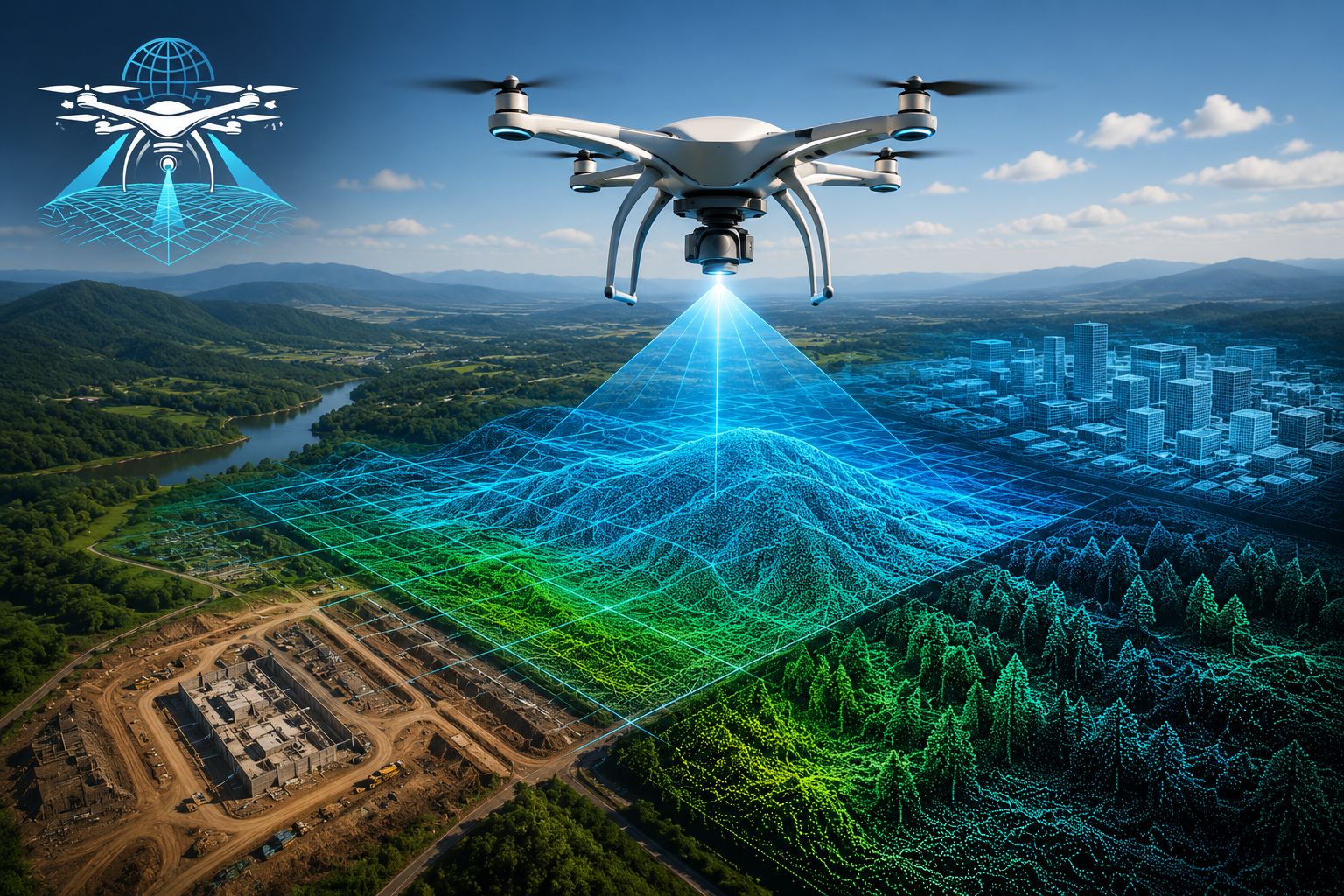
Drone Land Surveying: How It Works
Core Technology Behind Drones in Surveying
- LiDAR (Light detection and Ranging): Offers an extremely precise elevation model.
- Photogrammetry: It creates 3-D mapping by the overlap of aerial images.
- Thermal Imaging: Helps detect heat leaks, pipeline damage, or vegetation stress.
Advantages in Real Projects
- A drone building survey can scan rooftops, industrial complexes, or hazardous zones without putting workers at risk.
- Large farmland areas can be surveyed in under an hour using drone surveying services, giving farmers faster insights for crop planning.
- The drone topographic survey cost is often cheaper for projects spanning hundreds of acres because fewer ground staff are needed.
Speed and Efficiency: The Biggest Difference
Here’s a practical example:
- A 100-acre construction site traditionally takes 2–3 weeks to survey with a crew.
- The same project, using drones, can be completed in 2–3 days with detailed outputs.
The reason? Drones gather thousands of data points in a single flight. That not only reduces field time but also minimizes delays caused by weather or inaccessible terrain.
Comparing Accuracy: Is One Better?
- Traditional methods remain slightly more precise for boundary surveys and small-scale projects where millimetre accuracy is required.
- Drone-based surveys deliver accuracy within 2–5 cm, good enough for almost all construction, mining, and infrastructure applications.
In other words, drones may not completely replace survey crews for legal land boundaries, but they are more than capable of handling most operational needs.
Cost Analysis: Drone vs. Traditional
FactorTraditional SurveyingDrone Surveying Services
| Factor | Traditional Surveying | Drone Surveying Services |
| Field Time | High (days to weeks) | Low (hours to days) |
| Manpower Required | Large crew | Small team (1–2 operators) |
| Safety Concerns | Higher risk in rough terrain | Minimal (no direct exposure) |
| Drone Topographic Survey Cost | More expensive on large projects | Lower due to reduced labour |
| Data Detail | High but slower to produce | High with quick processing |
Real-World Case Studies
Construction Industry
A major highway project in the US reduced its surveying time by 70% using drone mapping. Engineers received 3D topographic models almost instantly, keeping the project on track.
Agriculture
Farmers use drones for topographic and vegetation mapping, cutting costs of manual inspections and boosting yield planning.
Building Surveys
A drone building survey is now standard practice for large warehouses and industrial roofs. Traditional surveys would have required scaffolding and manual climbing, but drones finish the job in minutes.
Safety and Risk Management
One of the most overlooked benefits of drone surveying services is safety. Surveyors no longer need to climb unstable structures, walk through swampy land, or spend hours near busy roads. Drones handle the dangerous work while humans monitor from a safe distance.
This isn’t just about reducing accidents. It also means lower insurance costs and fewer delays due to workplace risks.
Environmental and Accessibility Benefits
Traditional methods are often ineffective for a while in areas with dense forests or steep slopes. They also have restricted access. Drones, however, are able to hover over these areas and collect accurate data without impacting the environment.
For instance, aerial surveying services provide a unique advantage for conservation groups monitoring forests, rivers, or erosion patterns. They gain high-quality data without heavy machinery disrupting natural ecosystems.
Also, platforms like Skye Link offer aerial data collection with certified pilots and minimal on-ground impact, making them a strong option for projects that require both precision and environmental care.
Future Trends: Where Drone Land Surveying is Heading
- Integration of AI-based data processing for even faster map creation.
- Wider use of drones in smart cities and urban planning.
- Growing demand for aerial surveying services in renewable energy projects like wind farms and solar installations.
Industry experts believe drones will eventually become the default survey method, with traditional tools only used in highly specialized cases.
Why This Comparison Matters
This is what it all boils to: If your project isn’t heavily controlled or requires precision at the boundary, traditional methods are the right choice. However, for larger-scale projects in which speed, cost, and safety are the most important factors, drone surveying is the better option.
Companies such as Drone LiDAR Mapping have already shown that drones are superior to traditional methods in real-world scenarios. Through combining aerial expertise and precise technology, they’ve set an entirely new standard in the field.
Choosing the Right Survey for Your Project
The debate about drones and traditional surveying doesn’t revolve around either being superior to the other. It’s about choosing the best device for the right circumstances. However, as industries require faster turnaround times and safer working practices, drones are clearly winning ground.
Whether it’s a drone building survey, calculating drone topographic survey cost, or opting for aerial surveying services, the key is choosing a method that saves time, reduces risks, and ensures accuracy.
If you’re ready to step into smarter surveying, get in touch with Drone LiDAR Mapping today and see how their expertise can give your project the edge.