The surveying and mapping industry has experienced rapid development because of the newly developed drone technology. Traditional land surveys once required large crews, heavy equipment, and long timelines to complete mapping projects. Drones now provide surveying and mapping professionals with a new method to collect geospatial data which delivers faster and safer and more precise results.
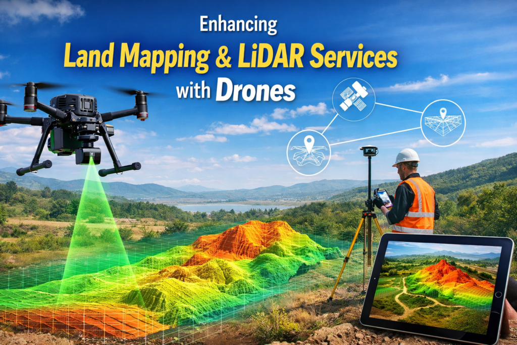
Drone LiDAR Mapping and other Land Mapping and LiDAR Service companies now utilize advanced drone-based LiDAR technology to collect accurate terrain data which they can obtain in less time than traditional methods. Skyelink and other modern platforms provide engineers and developers and surveyors with services which enable them to finish their work faster while achieving great precision.
The article investigates how drones improve land mapping and LiDAR services while showing their increased use in contemporary surveying tasks.
The Evolution of Land Mapping and Surveying
The traditional method of land mapping needs manual fieldwork which uses total stations and GPS devices together with ground crews who traverse all types of terrain. The techniques used in this process generate precise results but they consume both time and manpower resources while creating high expenses.
The introduction of drone technology has brought a total transformation to this procedure. Surveyors now have the ability to conduct aerial mapping operations through the combination of aerial platforms which carry LiDAR sensors and high-resolution cameras.
Drones enable professionals to conduct surveying and mapping operations which allow them to:
- Complete their work within hours when surveying vast areas of land
- Reach difficult and dangerous areas
- Obtain high-definition data about terrain features and elevation points
- Achieve lower total project expenses
The construction sector and infrastructure development field together with environmental research and land planning activities have adopted drone-based LiDAR mapping because it provides an essential tool for their aerial surveying needs.
Understanding Drone LiDAR Technology
LiDAR (Light Detection and Ranging) operates as a remote sensing system which uses laser beams for distance measurement between its sensor and the ground. Aerial drones equipped with LiDAR systems have the capability to capture data at a rate of millions of points each second which results in the creation of extremely accurate three-dimensional models that depict both terrain features and manmade structures.
LiDAR provides surveyors with the ability to map ground surfaces in forested and dense vegetation areas because it can see through plants which traditional aerial photography cannot.
The professional mapping provider Drone LiDAR Mapping uses this technology to create accurate mapping solutions which they use for various applications that include:
- Topographic surveys
- Infrastructure planning
- Environmental analysis
- Utility mapping
- Construction site planning
Surveyors can produce digital elevation models (DEMs) and contour maps and precise terrain models through drone LiDAR systems which work at a faster pace than traditional surveying techniques.
How Drones Improve Land Mapping Efficiency
Faster Data Collection
Drone surveying provides its most significant benefit through its ability to operate at high speeds. A single LiDAR-equipped drone can complete aerial surveys of 1000 acres during one operational flight. The process needs less time because of this development which enables faster field data gathering.
The time required to finish projects that used to need ground crews for weeks now reduced to several hours which helps companies start their planning and development activities earlier.
High Accuracy and Detailed Data
Modern measurement technology from LiDAR sensors achieves extremely accurate results which reach centimeter-level precision. Engineers and construction planners and regulatory authorities need this level of detail.
Land Mapping and LiDAR Services enable surveyors to develop point clouds and 3D terrain models which assist project teams in making improved decisions.
Improved Safety for Survey Teams
Most land surveying projects require work in hazardous environments which include steep slopes and dense forests and construction areas. The presence of crews in these territories creates greater security threats.
Drone surveying provides safe aerial data collection through its ability to collect information without needing physical presence. Surveyors can safely collect all necessary data by using drones to fly above the terrain instead of walking through the challenging landscape.
Cost Efficiency for Large Projects
When clients evaluate lidar drone survey costs, they discover that drone surveying provides more economical solutions than their traditional methods for large projects.
Drone surveys reduce costs through three methods which include:
- The process needs fewer workers
- The process needs less field investigation time
- The process needs fewer resources and operational costs
- The process enables quicker project completion
Drone LiDAR surveys become an appealing option for developers and engineering firms because they provide cost-effective solutions which work within their strict project deadlines.
Meeting ALTA Survey Requirements with Drone Data
Commercial real estate transactions and development planning and legal documentation both require ALTA/NSPS land title surveys as a standard requirement. The surveys employ rigorous standards which enable precise documentation of property boundaries and all building features and easement areas.
Boundary verification needs traditional fieldwork but drone mapping technology helps alta surveys because it delivers comprehensive aerial photography and topographic data.
Drone LiDAR data helps surveyors:
- Identify site features and improvements
- Map terrain elevations accurately
- Support boundary and infrastructure planning
- Provide visual documentation of the surveyed area
The combination of drone data with traditional surveying techniques enables professionals to conduct ALTA surveys in a more efficient manner while adhering to all regulatory requirements.
Applications of Drone LiDAR Mapping
Drone LiDAR technology has become a standard tool used throughout various industrial sectors. The technology finds its most common uses in these three areas:
Construction and Site Development
Developers use drone mapping to analyze land conditions, measure terrain elevations, and plan construction projects more effectively.
Infrastructure and Transportation
Engineers use drone LiDAR surveys to create road designs and develop bridge plans and construct railway systems.
Environmental and Forestry Analysis
LiDAR technology enables researchers to conduct precise studies of vegetation and terrain alterations and environmental effects.
Utility and Energy Projects
Utility companies use drone mapping to conduct safe and efficient inspections of their power lines and pipelines and extensive infrastructure systems.
Drones have become vital for surveying and mapping work because these tools provide essential support to contemporary geospatial fields.
The Role of Professional Drone Mapping Providers
Drones have become common in the market, but specialized professionals must operate drones to obtain accurate data and conduct proper analysis.
The specialized company Drone LiDAR Mapping uses advanced technology and skilled pilots together with their professional data processing system to deliver dependable outcomes for intricate projects.
Business access to advanced aerial mapping solutions through Skyelink enables them to acquire industry-standard technology which delivers vital information for their development and planning requirements.
The professional services deliver:
- Accurate processing of LiDAR data
- All necessary flight planning activities together with compliance requirements
- Delivery of high-standard mapping products
- The project produces dependable results for engineering and construction work
The Future of Drone-Based Land Mapping
Drone technology experiences rapid progress through ongoing improvements of LiDAR sensors and AI data processing systems and autonomous flight capabilities. The latest technical progress will boost aerial surveying operations through improved speed and precise results.
Aerial mapping using drone LiDAR technology will achieve higher efficiency levels within the next few years, which will establish it as the standard method for land mapping and infrastructure planning and environmental monitoring activities.
Companies that invest in Land Mapping and LiDAR Services today will establish themselves as leaders of this technological change.
Conclusion
The surveying industry has experienced a complete transformation through the development of drone technology which delivers land mapping results that are both faster and safer and more precise than conventional methods. Drones equipped with LiDAR sensors have the ability to capture intricate surface elevation data which enables construction projects and infrastructure development and environmental research to proceed.
Drones for surveying and mapping deliver major benefits to projects because they help to reduce project duration and enhance overall precision when compared to standard surveying techniques. The combination of competitive lidar drone survey pricing and drone-based systems which fulfill alta survey needs has turned drone surveys into essential tools for contemporary construction projects.
Through its partnership with Drone LiDAR Mapping and its use of Skyelink advanced technological platforms businesses can obtain effective aerial mapping services which produce dependable outcomes that accelerate project development.


